
Maspeth, in a western corner of Queens east of Greenpoint and Williamsburg, Brooklyn and west of Middle Village, is stuck between the grit of Brooklyn and the airy, suburban feel of its eastern and southern neighbors, Middle Village and Glendale. Maspeth was first settled by Native-Americans for centuries before the middle-1600s and by the Dutch and English after that. It was absorbed by a newer settlement to the east (named, appropriately, Newtown—the present-day Elmhurst), became a part of the borough of Queens, and then New York City in 1898. “Maspeth” is derived from Delaware Indian terms that have, by different accounts, meant “great brook” or “bad water place”; the latter is appropriate, since Newtown Creek, noxious through most of its latter-day history, is nearby. The name dates back to Dutch records in the 1630s.
Beginning in the 1790s DeWitt Clinton, mayor of NYC between 1803-1815 and New York State Governor from 1817-1823 and 1825-1828, resided in a mansion built in 1725 at present-day 56th Terrace and 58th St. Plans for the Erie Canal were made in the two-story mansion, which over the decades became a boardinghouse and farmhouse, finally burning down in 1933. The area’s non-descript industrial these days; the mansion was remembered by the Clinton Diner at Maspeth Ave. and Rust St., which stood near where Clinton’s homestead would be. Later renamed Goodfellas Diner after the 1990 Scorsese film, it too suffered a devastating fire. Nearby, Richard Upjohn’s 1847 St. Saviour’s Church had to be dismantled when a developer bought the property and built warehousing. For 17 years, it has awaited reassembly.
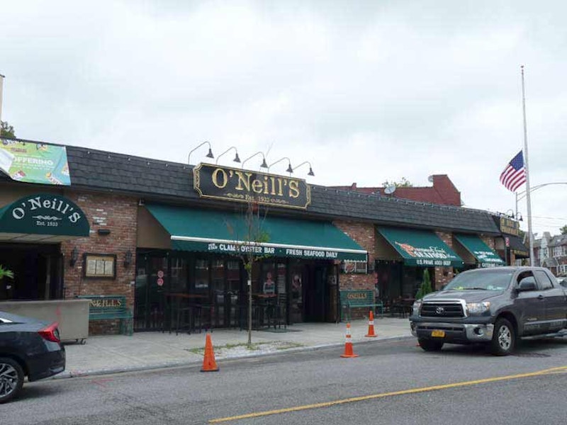
Above is one of Maspeth’s beloved taverns, O’Neill’s, at 53rd Dr. and 65th Pl. It opened as the Plateau Tavern by George O’Neill, Sr. the day Prohibition ended on December 5, 1933, and became a fully-fledged restaurant in 1956. O’Neill’s persevered after suffering a damaging fire in 2011.

Stopping by the former location of the Haberman Long Island Rail Road station at 49th St. and 56th Rd. Once fairly busy, by 1998 there were very few people getting on and off to work at the various factories and industries in this isolated section of Maspeth, and the LIRR closed the station along with several others on the “Montauk Branch” running from Long Island City to Jamaica via Maspeth, Glendale, and Richmond Hill. In 1998, when I rode the line, Haberman looked much as it does today: a clear patch in the weeds along the tracks, with no station sign. According to the late LIRR historian Vincent Seyfried, the station originally opened in 1892 and was named for the Haberman Steel Enamel Works in Berlin Village, a name formerly applied to this section of town, which featured a number of German immigrants.
This is one of the relatively few streets in NYC that has a grade crossing. The gates come down when a freight train is using the tracks.

For decades Maspeth has been a Polish and eastern European enclave. As early as 1890, Polish immigrants chose Maspeth in which to settle. In 1921, the Polish National Home (or in Polish, “Polski Dom Narodowy”) was founded to teach younger generations about their Polish heritage. This building was erected in 1934 on 56th Rd. near 64th St. Members of this organization opened the 1939 World’s Fair, dedicated Maurice Park and participated in the opening of the Kosciuszko Bridge. Maspeth has welcomed a new wave of Polish immigrants over the last two decades; storefronts along Grand and Maspeth Aves. reveal that the Polish tongue is the most popular foreign language in town, and Polish food may be the most popular cuisine.
![]()
One of the most gorgeous buildings in Queens. The first Church of the Transfiguration was built in 1909 to serve the swelling population of Lithuanian immigrants. The present structure at Perry Ave. near 64th St. dates from 1962. Lithuanian folk art elements adorn the inside of the church. The Lithuanian phrase above the doors, Mano Namai Maldos Namai means “My house is a house of prayer.” Multiple Masses are still celebrated in the Lithuanian language each weekend. A replica of a Lithuanian roadside shrine sits in the churchyard of Transfiguration R.C. Church.
The first Transfiguration church was built in 1909 on Hull Ave. to serve the swelling population of Lithuanian immigrants. After that church burned down twice, the congregation moved to its present location on Perry Ave., into what was St. Stanislaus Kostka’s original building (see below). St. Stan’s then built a new church on the site of Maspeth’s defunct Quaker Meeting house and cemetery. Stanislaus Kostka (1550-1568) was a Polish Jesuit novice who walked from Vienna to Rome, likely contracting malaria on the journey, from which he died at 17. He was canonized in 1726.

Holy Cross Roman Catholic Church on 56th Rd. between 61st and 64th Sts. may take a back seat to the nearby Church of the Transfiguration as far as flash is concerned, but the parish, established in 1912, is one of a few in northern Brooklyn and southwest Queens visited by Cardinal Karol Wojtyla before he ascended to the papacy and became known as John Paul II in 1978. The church message board is punctuated with Polish translations of English listings. When JPII was canonized, or made a saint, in 2014, the block was sub-named Pope John Paul II Way, and in an unusual situation (I haven’t seen it before elsewhere) many of the private homes on the street have hung a Department of Transportation-issued Pope John Paul II Way street sign.
The Queens County Hotel, built in 1851 on today’s Grand Ave. and Remsen Pl., served farmers from Long Island who were hauling wagon loads of produce to Brooklyn’s Wallabout Market. The hotel was one of many that sprang up on Grand Ave. The wheelwright (see next entry) also served the farm workers. It was a long trip by wagon, and the weary wagon drivers and passengers would stay the night and take a meal and drinks.

Gustav Haflinger, Maspeth’s town butcher, built this house at Brown Pl. and 58th Ave. in the 1880s. Subsequent owners of his house have taken care to keep it in good condition, down to the paint detailing on the railings. Several houses along Brown Pl. and 58th Ave. exhibit one-of-a-kind wooden craftsmanship.

Mt. Olivet Cemetery, whose front gate at Grand Ave. and Remsen Pl. is shown here, was founded as an Episcopal cemetery in 1850 and opened to all faiths the following year. One of the founders, James Maurice, was a U.S. Congressman, Maspeth landholder and founder of the now disassembled St. Saviour’s Church. He’s buried here along with his two brothers and three sisters, none of whom married. Compared to larger cemeteries around town like Green-Wood, Woodlawn and Evergreens, Mt. Olivet is short on star power; however, Prince Matchabelli and Helena Rubenstein are buried here, as is gangster Jack “Legs” Diamond, who according to legend, was a good dancer, hence the nickname.
The cemetery, named for Jerusalem’s Mount of Olives where according to New Testament tradition, Jesus preached, was arrested at the Garden of Gethsemane and ascended into Heaven, occupies an irregular site stretching from Grand and 58th Aves. on the north to Eliot Ave. on the south, and from the rear of properties on 68th St. on the east to the rear of properties on 58th Rd., 66th St., 59th Ave., 64th St., 60th Ave., 66th St. again, 60th Rd., and Mount Olivet Crescent, on the west.

The site of Elmhurst Park was once the location of two KeySpan Newtown gas holders, a highway landmark popularly known as the “Elmhurst gas tanks.” With the support of the community, the site was sold by KeySpan to the City of New York for $1, cleaned up and returned to the public as open space. The park now features lush lawns, jogging paths, seating, sculpture, comfort stations, safety lighting, and more than 620 trees. The playground, designed for young children, is energy-themed, in keeping with the site’s history. At the playground, kids can pedal a stationary bike to provide a light effect on a nearby column. The new park is also in keeping with sustainable practices. Storm water at the site is collected in an underground retention system to reduce the amount of water flowing into the sewer pipes in the street.

The streets of Long Island City, Ridgewood and to a lesser degree, Woodside, are lined with blond bricked Matthews Model Flats, each unit produced for $8000 in 1915 by Gustave X. Mathews, who is virtually unknown today but responsible for much classic residential architecture in Queens. The distinctive yellow bricks were produced in the kilns of Balthazar Kreischer’s brick works in the far reaches of Staten Island. (The Kriescher and Long Island City stalwarts, the Steinways, were linked by marriage.) These buildings, along Grand Ave. at 80th St., were the final Mathews Flats built in NYC and were executed by architect Louis Allmendinger.

Of the many bridges that cross the noxious and noisome Newtown Creek, which includes the Pulaski (McGuiness Blvd.), J.J. Byrne (Greenpoint Ave.) Kosciuszko (Brooklyn-Queens Expressway), the Metropolitan Avenue bridge, and the late lamented Penny Bridge, my favorite is the rattling Grand St. Bridge, which connects outlandishly remote sections of Brooklyn and Queens, two neighborhoods in East Williamsburg and western Maspeth you wouldn’t visit unless you worked there. While the other Newtown Creek bridges are relatively bland products of the mid-to-late 20th century, the Grand Street Bridge is a 1900 swing bridge that looks like something you’d put together with an erector set as a kid.
The bridge is scheduled to be torn down (this has been discussed for about a decade) and replaced with a wider, traffic-friendly bridge that will no doubt be purely functional. See this artifact while you can.
—Kevin Walsh is the webmaster of the award-winning website Forgotten NY, and the author of the books Forgotten New York (HarperCollins, 2006) and also, with the Greater Astoria Historical Society, Forgotten Queens (Arcadia, 2013)