
My idea was to walk from Jamaica Estates, one of two ritzy areas in northern Jamaica, all the way home to Little Neck. When I was bicycling throughout Queens between about 1993 and 2007 I passed through Jamaica Estates a few times, and its partner neighborhood to the east, Holliswood, a few times. I saw little of Jamaica Estates because I found it relatively uninteresting. I was seeking grittier fare as far as explorations went at the time, and I rarely went into Holliswood because it’s unmercifully hilly. Since I do most urban exploring on foot these days, Jamaica Hills and Holliswood are more attainable.

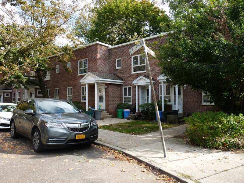
Heading north on 188th St. (aka Saul Weprin St., for a local politician) into the heart of Fresh Meadows. It’s known best for the extensive residential community of the same name centered at 188th St. and the Long Island Expressway that was constructed there between 1946 and 1949 by the New York Life Insurance company. Prior to the apartment complex, the area’s claim to fame was Fresh Meadows County Club and golf course that hosted the U.S. Open in 1932. The housing mix is three-story apartment buildings in garden settings, with a couple of high-rise towers.
Fresh Meadows takes its name from its contrast to neighboring Flushing, whose name is a transliteration of the Dutch “Vlissingen” meaning “salt meadow valley.” Ponds and creeks running through the neighboring area to the southeast were likely “fresher” or free of salt, and so Fresh Meadows replaced the harsher-sounding older name for the region, Black Stump, which apparently referred to burned, blackened stumps that marked the edges of farms. Until about 2000, one of Queens’ last remaining farms, belonging to the Klein family, sold produce on a roadside stand at 73rd Ave. and 193rd St.

Fresh Meadows became the location of Queens’ first Hooters in the early-2000s. My only experience with Hooters was in January 1993, when I was in Minneapolis at the Mall of America and we found it open late at night after a long flight. My friend Vinny L. and I flew out to Minny to take in a couple of Minnesota North Stars games. This Hooters location was formerly the Future Diner, which was visited by Bill Clinton during his successful 1992 presidential campaign, returning for a visit the following year as President.

These type of street signs, blue letters on off-white signs, were standard issue in Queens between 1964 and about 1984, at which time they were replaced by today’s white on green design. When I began FNY in 1998, there were still a few dozen of the white signs around, but they’ve all been weeded out by the Department of Transportation, except for these four signs, on two separate poles. Fresh Meadows is a semi-private development, which may explain these signs’ longevity, but there are new signs elsewhere in the complex. Already, some have been replaced.

Peck Ave. is among Queens’ most unusual roads. For most of its length, it serves as the south “service road” of the Kissena Park Corridor, which was built on the route of the old Stewart Railroad which connected Flushing and Garden City in the 1870s. Peck Ave. runs through Flushing, Fresh Meadows, and Hollis Hills in five different sections; in its longest section, it runs south of Corridor Park, while Underhill Ave. runs along the north. At one time, Peck and Underhill were mapped out to the Nassau County line along the route of the Motor Parkway, but were never built that far. Peck Ave. is named in honor of longtime Flushing resident and property owner Isaac Peck (1824-1894). He owned a department store in College Point for many years. Members of the Peck family are buried in St. George Churchyard on Main Street in downtown Flushing.

Here’s Hollis Court Blvd. at 195th Pl. This wide road cuts diagonally across the grid; it’s not ancient, but did exist as Queens Rd. in the early part of the 20th century. Hollis Court Blvd. originally ran in a straight line between eastern Flushing southeast to Hollis Hills, but the construction of Cunningham Park as well as the Long Island and Clearview Expressways split it into three sections. The “Court” was added to the road’s name likely to class it up a bit as new housing was springing up along its route.
According to The New York Times, the name “Hollis” comes via Frederick W. Dunton, the first developer of the area we call Hollis now, which was once known as East Jamaica. He was a native of Hollis, New Hampshire. Originally, Hollis, a parallelogram defined by 180th St., Francis Lewis Blvd., Hillside Ave. and 104th Ave. and bisected by Jamaica Ave., was settled by the Dutch in the colonial era and centered around the present intersection of Jamaica Ave. and Hollis Ave., which was once called Old Country Rd.
I know little about Clear Springs, a tiny sub-neighborhood in Bayside consisting of some older dwellings and the Trinity Baptist Church of Bayside, concentrated on 48th Ave. at about 208th St. I understand from newspaper clippings it is, or had been, a small cluster of African-Americans in Bayside. I know about Clear Springs from Mandingo Tshaka, lifelong Baysider and late activist, who helped get the city to restore a Black cemetery on 46th St. and 165th St. that had been paved over for a playground by Robert Moses in the 1930s.
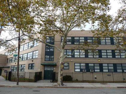
The Marie Curie Middle School (MS 158) and public park are named for Polish-naturalized French physicist Marie Curie (1867-1934). She won the Nobel Prize in Chemistry with her French husband, Pierre Curie, and on her own in 1911. she died from radiation poisoning at 66. Her life was memorialized in a 1943 film starring Greer Garson and Walter Pidgeon. I was struck by the unusual design of the school, which features three stories of extra-wide windows and an oval rear. I was unaware of the presence of a public pool in Marie Curie Playground until now.

One of the real obscurities of Bayside, and one I’d forgotten about the past few years, is the presence of the St. George Russian Orthodox Church on 46th Ave. just west of Bell Blvd. It’s the smallest such church I’ve ever seen, compared to the large, onion-domed numbers I’m aware of in Whitestone and Williamsburg, while the only onion dome to be seen here is on the ID sign. The services list is, unusually, posted in English. Its website claims the church is over a century old and this may be the original building.

PS 31, on 46th Rd. just west of Bell Blvd., is one of the most recognizable buildings in southern Bayside and can be seen from blocks surrounding it. Its tower was repainted in wedding-cake white years ago. I find it reminiscent of the clock tower at Poly Prep in Bay Ridge, without the clocks.
It’s the region’s oldest public school. Established in 1842, the original one-room schoolhouse was Bayside’s first school, located on the W.L. Titus Farm on Rocky Hill Rd. In 1842 a sum of $360 was voted and raised to build the school on the Titus farm near present-day 48th Ave. This building served the community until 1859. In 1864 the trustees, at the request of 16 voters, called a special meeting to vote for incorporating the school district as a Union Free School District. In 1883 the two-room school building was moved to the site of present day P.S. 31. After the consolidation of the Borough of Queens with the City of New York, this school became known as P.S. 31. By 1950 the larger building we know today was built on the old site which still serves the community.
—Kevin Walsh is the webmaster of the award-winning website Forgotten NY, and the author of the books Forgotten New York (HarperCollins, 2006) and also, with the Greater Astoria Historical Society, Forgotten Queens (Arcadia, 2013)