
The name “Dyker” is a puzzler for Brooklyn lexicologists. In Brooklyn By Name, Leonard Benardo and Jennifer Weiss assert that Dutch farmers who built dikes to drain the area’s wetlands in the colonial era gave it its name. However Van Dyke is a common Dutch name and a family of that name did have a hand in its development in the mid-1700s. Dyker Heights was more strictly defined when the Gowanus Expressway was completed in 1964, as the neighborhood’s boundaries can be set at 86th St. (and the Dyker Park Golf Course) the expressway, 65th St. and 14th Ave. It’s overwhelmingly residential and the only business streets are Fort Hamilton Parkway, 13th Ave., and parts of 11th. The neighborhood is most heavily chronicled during the Christmas season, when many locals construct extravagant displays, especially along 84th St. between 11th and 12th Aves.
Though my usual movie theater growing up in Bay Ridge was the Dyker on 86th St. and Gelston Ave., as a kid I had four theaters to choose from: the Dyker, the Harbor on 4th Ave. and 93rd St., the Alpine on 5th Ave. and Bay Ridge Ave. and the Fortway at Fort Hamilton Parkway and 68th St. I never was and still am not a big moviegoer. The last one I saw was Interstellar in late-2014.
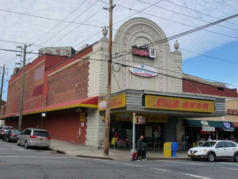
However, in the days before cable TV, you had a lot of theater choices. What in the 1970s was called “Pay TV” heralded the end of multiple neighborhood theaters and the Dyker prominently displayed this message on its marquee in the early-1970s: “Stop Pay TV!” Pay TV wasn’t stopped, and the Dyker gave up by the mid-70s, with one of the last features being Willard. I prefer the days when you could pick and choose from neighborhood theaters. The Fortway, at least, still looks like it was a theater. It opened on October 21, 1927 for movies and vaudeville acts and was a one-film theater for most of its existence, but as other theaters closed, the Fortway became a triplex in the 1970s and expanded to six screens in the 1980s. Eventually, it succumbed in 2005 and became a supermarket in 2007.
One of the long-lost aspects of neighborhood theaters in the 1970s is that they were often turned into rock concert venues. The Grateful Dead played midweek matinee shows at the 46th Street Rock Palace in that era, and Jethro Tull, the Kinks and other classic acts performed at the Ritz in Staten Island. The Fortway wasn’t outdone. Chuck Berry appeared here in 1972 touring behind his only #1 hit: “My Ding-A-Ling.”

Occasionally Dyker Heights will surprise you with an aged building like this one, between 63rd and 64th on 12th Ave., the Angel Guardian Home (later Mercy First) which sheltered unwed mothers and their children beginning in 1899. In that year this part of town was far removed from anything else, but there was still a certain dignity placed into the construction of housing for people who, in that era, were mostly shunned by society. The building served as a senior center in its later years.
The Sisters of Mercy put the building up for sale in late-2017; it was sold to developer Scott Barone for $37.5 million and it was feared that the distinguished building would be razed for condos. Barone divided the property into three lots and sold two of them, and ancillary buildings on the campus—thankfully not the main orphanage—were torn down. Plans call for a school to go up in their place. The main building has now been protected by the Landmarks Preservation Commission, and will not be razed.

A corridor park named for Scandinavian explorer Leif Erikson runs through Dyker Heights where it borders Bay Ridge, from 4th Ave. to Fort Hamilton Parkway, interrupted only by the Gowanus Expressway, which was bruited through between 1959 and 1964.
Erikson (960-1020) was probably the first European to set foot on the American continent, nearly 500 years before Christopher Columbus’ voyages. He was born in Iceland around 960, the son of Eric the Red, an Icelandic king who discovered and colonized Greenland. The Icelandic Sagas offer two explanations of Erikson’s famous voyage. One suggests that Erikson, en route to Greenland, was blown off course and arrived on the northeastern coast of North America, about where Labrador and Newfoundland are found today. In the other, he organized an expedition to confirm a previous report of hilly, heavily forested land west of Greenland.
Scandinavians first began moving to Bay Ridge and Sunset Park in the 1820s, and by the early- and mid-1900s made up a nearly majority population in the neighborhoods. When NYC bought a parcel of properties between 4th Ave. and FHP in the 1930s, Parks Commissioner and traffic czar Robert Moses developed them as a unified park and it was named Leif Erikson Square to acknowledge the presence of the Norse here. The Norwegian Day Parade is still held on 5th Ave. in May, though the Scandinavian population here has severely diminished since the 1960s.
Shown here on a recent Forgotten New York tour, tourgoers gather at Leif Erikson Square’s runestone plaque, erected in 1939. Crown Prince Olav, who ruled as the popular Olav V of Norway from 1957-1991, dedicated this replica of a Viking rune stone in Tune, Norway on a 1939 visit. The stone stands on Leif Erikson Square just east of 4th Ave. (Tune, southeast of Oslo near the Swedish border, was incorporated into the town of Sarpsborg in 1992.)

Ovington Ave. is one of Bay Ridge and Dyker Heights’ oldest cross streets, and it meanders gently against the grid that was later laid down around it, so it was never assigned a street number. The Ovington family farm was located in the area since just after the colonial era; a group of artists and artisans purchased the farm in the 1850s, calling it Ovington Village, and Ovington Ave. was the road between the Athenaeum (concert hall) and the village. It was later built up and lined with spacious homes on 400-foot-wide plots. Family scion Mary White Ovington helped found the NAACP. St. Nicholas Home, shown above, 425 Ovington, is a former nurses’ training facility; this building has been here for over a century.

Stewart Ave. runs two blocks between 74th and 72nd Sts., and again from 71st to Ovington. It had run continuously but in about 1981-1982, tract housing was built on the segment between 71st and 72nd. It’s a mostly unpaved or dirt road from 72nd to 73rd but a close looks reveals that segment had been paved decades ago. The portion between 71st and Ovington survives because it’s used as a driveway by the owner of an adjacent house.
In the 1800s in Dyker Heights and Bay Ridge, pathways from the colonial era were still the only way to get around, as the area was dotted with family farms and villages such as the Ovington settlement. The well-to-do were already building large estates along the shoreline as the black squares along Shore Rd. indicate. The present street grid was being surveyed in 1873 and while most east-west streets are not even shown yet, 2nd, 3rd and 4th Aves. were already in place, with a horsecar line along Third. Remarkably, the road still exists today, one of the only unpaved streets in NYC.

I was fooled recently when, stumbling through Dyker Heights, I spotted a lawn icon showing a bit of leg. I was reminded of St. Peregrine of the Friar Order of the Servants of Mary (the Servites), the patron saint of cancer sufferers, showing off the varicose vein that went untreated and became cancerous. He was later miraculously cured. I’ve been told, though, that there’s more than one saint showing off a leg wound, and this one happens to be St. Roch or St. Rocco (spellings vary by country). Traditionally invoked for help against the bubonic plague in the 14th century, the legend of Roch was based on an older figure, St. Racho, who lived in the 7th century.
The 14th-century Roch, according to legend, hailed from Montpelier, France, a follower of St. Francis who ministered to the sick during one of the waves of black plague that spread through Europe. After contracting the plague himself he retreated to a forest and made a hut from leaves and boughs, and was supplied with bread and water from a neighboring town by a helpful nobleman’s dog he’d befriended (hence the image of a dog in his iconography). He was later accused of spying against the local government and died in prison.
During subsequent attacks of the plague throughout Europe, his name was invoked and a cult sprung up around his name. Churches and cathedrals were dedicated to him, as well as entire religious orders. “Roch’s” status as a pilgrim who suffered plague is paramount in his iconography. “The sight of Roch scarred by the plague yet alive and healthy must have been an emotionally charged image of a promised cure. Here was literal proof that one could survive the plague, a saint who had triumphed over the disease in his own flesh.”

St. Ephrem’s Church, 75th St. and Fort Hamilton Parkway. Information online about the church is hard to come by, but I believe the church is “relatively” new, dating to the 1950s. Growing up in Bay Ridge, I lived near a pair of Catholic churches commemorating saints I’d never heard of, Anselm and Ephrem (we read sants’ lives as children). Anselm (1033-1109) was a Burgundian (today’s Italy) theologist and philosopher, who held the post of Archbishop of Canterbury while Ephrem (306-373) was a Syrian hymnist, theologian and deacon. It’s fitting that Bay Ridge, which has had many Syrian and Middle Eastern Catholics, would have a parish named for a Syrian.
St. Ephrem holds a place in New York Mets history, at least my personal Mets history. In October 1986 the Mets were playing the Houston Astros in a playoff game on the Saturday afternoon my cousin Eileen was going to get married here, at St. Ephrem. The wedding was at four; Lenny Dykstra hit the game winning blast at 3:30; and since I was living in an apartment at 7th Ave. and 73rd St. at the time, I strolled across McKinley Park to the church just after the ball sailed over the fence.

McKinley Park is triangle-shaped plot between 7th Ave., Fort Hamilton Parkway and 73rd St., with a neat bisection by 75th St.. The southern half contains basketball and tennis courts, while the northern has a playground, park house, and grassy park paths. McKinley Park was completed by the Parks Department in 1903 and named for President William McKinley (1843-1901), who was felled by an assassin’s bullet on September 6, 1901 and succeeded by Vice-President Theodore Roosevelt.
McKinley Park retains rolling hills that have been mostly flattened elsewhere in the neighborhood. The central hill with the flagpole is ideal for sledding in winters when NYC gets a lot of snow, which isn’t every year anymore. William McKinley Junior High School on Fort Hamilton Parkway can be seen at right.
—Kevin Walsh is the webmaster of the award-winning website Forgotten NY, and the author of the books Forgotten New York (HarperCollins, 2006) and also, with the Greater Astoria Historical Society, Forgotten Queens (Arcadia, 2013)