
There’s a New England undercurrent running through the Bronx. The New York Yankees’ rivalry with the Boston Red Sox began when the Sox’ owner Harry Frazee sold Babe Ruth, to the Yankees before the 1920 season, and the antagonism is legendary.
But there are other places and landmarks in the Bronx that point toward New England, such as the New England Thruway, the name that Interstate 95 takes between the confluence of the Bruckner Expressway and Hutchinson River Parkway and the Connecticut state line.
One of the Bronx’ longest roads is Boston Road, which arises at Third Ave. in Morrisania and roars northeast to the city line in Eastchester, with a break for the Bronx Zoo. In northeast Bronx it assumes the mantle of United States Route 1, which runs from Key West, Florida to northern Maine, and if you follow US 1, which is called the Boston Post Road for part of its route, you’ll catch sight of the Prudential Center and The Hancock Tower after several hours’ driving, though I-95 is much faster (see Eric Jaffe’s excellent The King’s Best Highway for the complete Boston Post Road story).
That brings us to the former New York, Westchester & Boston Railway. When conceived, it was assumed that it’d eventually reach Boston, but instead at its lengthiest, it ran from southern Mott Haven in the Bronx to two terminals in Westchester County, at White Plains and at Port Chester. Originally conceived in 1872, it was delayed for a few decades by the Panic of 1873. Once emerging from receivership in the early-1900s, the railroad began construction in 1906 and built north, with the northernmost stations at Rye and Port Chester opening in 1928 and 1929. When most stations opened in 1912, the NYW&B was considered state of the art for its time, taking power from overhead lines, no grade crossings, high platforms to enable comfortable boarding, and spacious, architecturally attractive ticket offices/station houses.
Despite its advantages, the NYW&B wasn’t a success. When it opened, the automobile industry was beginning to take off—by the 1920s, scenic parkways appeared to handle intracity auto traffic, and the NYW&B couldn’t compete as a commuter railroad because it ended its run in Mott Haven and riders had to detrain and switch to the 3rd Ave. El to get to Manhattan. It soldiered on for a decade, but declared bankruptcy in 1937, ending service.
But all was not lost. The City of New York saw an opportunity to expand service into Pelham Gardens and Eastchester, and purchased the NYW&B right of way, stations, and tracks. After making modifications like adding a third rail, the NYW&B became the Dyre Ave. Shuttle in 1940, and after new tracks were installed to connect it with the White Plains Rd. el in the 1950s, the full-fledged Dyre Ave. Line, today the home of the #5 train.
I walked the route, or the closest possible approximation along the tracks, from the Bronx Park East station northeast to Dyre Ave. It gave me a chance to traverse the Pelham Gardens and Eastchester sections of the Bronx, and approach both the subway route and the neighborhoods it travels through with a fresh perspective.
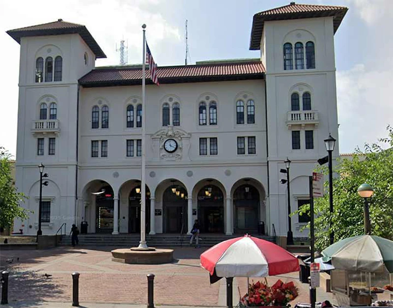
I didn’t start at the East 180th Street station at Morris Park Avenue, but will cite the station house, seen above, which is the largest in the New York City subway system. It was recently renovated and painted, and houses the station entrance turnstiles as well as some offices. It was formerly a police precinct house. The elevated platforms of the old NYW&B are still standing here. Until a track connection was made in the 1950s, a paper transfer was used to cross from the White Plains Line to these tracks. The station house bears the image of the NYW&B’s standard-bearer, the Roman messenger god Mercury, with his winged cap and symbol of a staff entwined with two snakes.
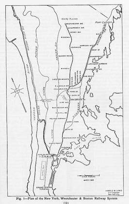
The New York, Westchester & Boston at its furthest extent in the 1930s, from Mott Haven in the south Bronx to mid-Westchester County with branches to White Plains and Port Chester. South of the 180th St. station, the NYW&B shared track with the old New York, New Haven and Hartford Railroad, of which there are still several stations surviving, in incredibly deteriorated states.
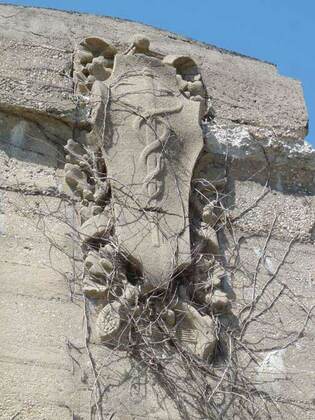
As stated before, the emblem of the New York, Westchester and Boston RR was the Roman god Mercury and his caduceus, or rod with two entwined snakes. North of 180th St. and south of Pelham Parkway, the NYW&B is generous in allowing traffic to pass, located on a concrete embankment with iron bridges over the cross streets. At many of these intersections you can find four caducei in concrete. North of Esplanade, though, the NYW&B travels in an open cut, forcing a number of detours.
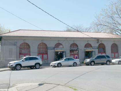
The Morris Park station, at which the Dyre Ave. Line/NYW&B enters a tunnel that runs for about 10 blocks, is the lone remaining Spanish Mission style station that’s still open; other stations to the south in the style at Westchester Ave. and Hunts Point are in ruins. Though NYW&B stations have been described as spacious, the addition of the high turnstiles has made them more cozy or cramped. In the Bronx, Morris Park is the northernmost station still bearing traces of the old caduceus symbol.
Before the MetroCard or now OMNY, fare collection on the Dyre Ave. line was unusual after working hours. At night, clerks working at the booths (who’d now start closing them) would use an Allen wrench to close the tops of the turnstiles and tie the slam gates open. Customers who’d come into the station were directed to enter through the slam gate, walk up to the platform and pay on the train. When the E. 180th St.-bound shuttle train arrived at the station, only one door on the train would open up. The customer entering the train would drop their exact fare into a Johnson Fare Box (the kind formerly used on buses).
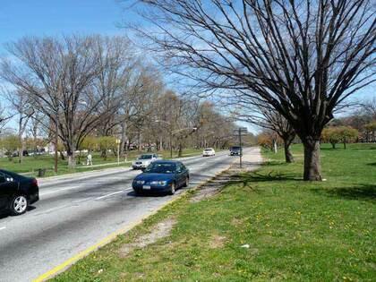
Beginning with the Pelham Parkway station at Alfred E. Santangelo Plaza, former NYW&B stations are more low-key and no-frills, with simple concrete buildings. There’s evidence of a former side entrance here, long since paved over. Santangelo was a U.S. Representative in Congress from 1957-1963. The station is just north of the Bronx and Pelham Parkway, which runs from Bronx Park, where it becomes East Fordham Rd., to the Bruckner Expressway, where it becomes Shore Rd. in Pelham Bay Park and connects to the Hutchinson River Parkway.
The Bronx and Pelham Parkway (its official name) was constructed in the early-20th century in the tradition of “garden trafficways” like Ocean Parkway and Eastern Parkway in Brooklyn, between Bronx and Pelham Bay Parks and bears close resemblance to Mosholu Parkway, i.e. a four-lane main road with access roadways flanking it. Unlike Mosholu, though, Pelham Parkway originally ran through open country; parcels for it were obtained from local landowners.
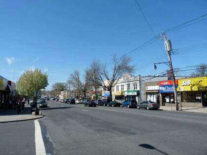
One of the Bronx’ more colorfully-named routes, Gun Hill Rd., seen here at Wilson Ave., begins at Mosholu Parkway at Van Cortlandt Park and runs generally east to the confluence of the Hutchinson River Parkway, New England Thruway and Bruckner Expressway. Most of it is actually “East” Gun Hill Road, with a short “West” Gun Hill Rd. between Mosholu and Jerome Ave., the divider between East and West Bronx streets. As is the case with Throg(g)s Neck, there’s a dispute whether the proper spelling is Gun Hill or one word, Gunhill.
The western section of the road near Van Cortlandt Park is the oldest part, with the eastern section gradually built out in the early-20th century. The Gun Hill, from which a group of Americans fired on British troops on January 25, 1777, is located within Woodlawn Cemetery. The Gun Hill Rd. station is located on the south side of the road between Seymour and Fenton Aves.
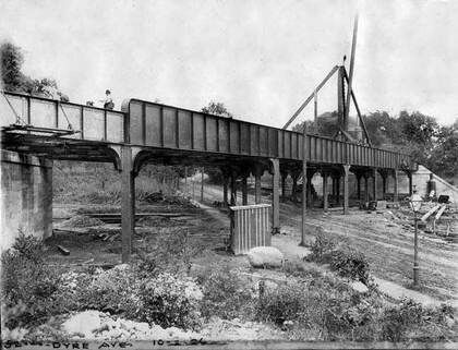
Dyre Ave. is a main traffic and shopping drag from Boston Road north into Mount Vernon, and the NYW&B built a station here that has become the end of the line for the IRT when it took over in 1940. It’s named for William Dyre, an early NYC mayor from 1680-1681. It was still a dirt road in 1906 when the railroad arrived. Note the gas lamp: though electric lamps were beginning to take over in 1906 there were still many gaslights, and would be until the 1920s. Photo courtesy Robert A. Bang Collection, John Tolley Archive.
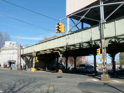
The Dyre Ave. trestle at the northern end of the line is today much the same except for the superstructure with station offices, added sometime during the 20th century. The old NYW&B extended well into Westchester County (plans called for an extension into Connecticut but the road went bankrupt before that happened). There are several station traces in Westchester.
Are there other NYC subways that descend from railroads? At least four in southern Brooklyn do: the D train (West End steam railroad); B/Q (Brooklyn, Flatbush and Coney Island); F (Culver) and N (Sea Beach). However, the NYW&B differs from them all because it’s of more recent vintage and never used steam engines. It was designed to take electric power from overhead wires from the start. When the city bought it, it installed a third rail on the surface.
—Kevin Walsh is the webmaster of the award-winning website Forgotten NY, and the author of the books Forgotten New York (HarperCollins, 2006) and also, with the Greater Astoria Historical Society, Forgotten Queens (Arcadia, 2013).