
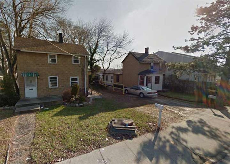
We begin in Sandy Ground, located at Bloomingdale and Woodrow Rds. The neighborhood was founded by New York City’s first community of free Blacks, oystermen who moved north from the Maryland shore to work the then-burgeoning oyster beds along the Staten Island shore. There are still a number of descendants of those settlers residing in Woodrow and Rossville today. After the water became too polluted in the 1910s, the oyster beds were condemned, and many residents moved away. Yet, the community’s unique identity persisted until the 1960s and 1970s, when suburban sprawl, bringing the anonymity that increasingly pervades Staten Island’s south shore, began to take over the area. In this photo we see a couple of the oystermen’s surviving dwellings on Bloomingdale Rd.
The Sandy Ground Historical Society, 1538 Woodrow Road at Lynbrook Ave., exhibits letters, photographs, film, art, quilts and rare books, all collected from area homes over the past few decades, in its collection. Call (718) 317-5796 for hours.

Many New Yorkers, if they have any impression of Staten Island at all, know it primarily from the small area of St. George that can be glimpsed when the ferry gets close to the island, and from the back of the boat when it’s returning to the ferry terminal at Battery Park. St. George is a neighborhood of winding streets (Staten Island, in its flatter areas, follows a rough grid plan, but in hilly areas, streets wind to around), steep, San-Francisco-style hills, mom-and pop shops, Victorian-era architecture (and a few Art Deco masterpieces as well). Staten Island courts and most governmental administrative buildings are here where Bay St. meets Richmond Terrace, including the imposing Borough Hall with its elegant clock tower, designed by Carrere and Hastings and completed in 1906. Its main hall displays 12 murals depicting early Staten Island life painted by F.C. Stahr. On weekends, St. George is a sleepy place; Bay St., except for its busy auto traffic, is almost deserted.
St. George was named for a land baron named George Law, who acquired waterfront rights at bargain prices. He agreed to relinquish some of the rights for a ferry terminal—provided it be named for him! Prominent residents of St. George have been New York State Governor Daniel Tompkins and subway bankroller August Belmont. Over the past 15 years, the St. George Theatre on Hyatt St., seen here, has been restored and now hosts musical performances from top acts known from Broadway, the movies and pop charts.

In 1836 Minthorne Tompkins (the son of Vice President Daniel Tompkins) and merchant William Staples established a ferry to Manhattan and founded the village at Bay and Water Sts. German immigrants built numerous breweries in the area in the 1800s, including Bachmann, Bechtel, and Piels, whose brewery was in business on Staten Island until 1963.
Among the most notable and strangest aspects of Stapleton’s history was the presence of the National Football League, which fielded a team known as the Staten Island Stapletons here from 1929 through 1932. The Stapes were a semi-pro team founded by restaurateur Dan Blaine in 1915, who played halfback for the team until 1924. The Stapes would play exhibitions against pro teams from the NFL and the 1920s version of the American Football League, and after they rolled up a 10-1-1 record in 1928, including a 3-1 record against NFL squads, the Stapes joined the NFL the next season, playing in tiny Thompson’s Stadium on Tompkins Ave., a site now occupied by Stapleton Housing. Led by halfback Ken Strong, a New York University graduate, the Stapletons compiled a 14-22-9 record against NFL competition in four years. The Stapes played an exhibition schedule in 1933, with some games against NFL teams, before Blaine folded the team and Strong joined the New York Giants.
Unfortunately, it appears that the old Paramount Theatre on Bay St., shown above, the home of vaudeville, movies and rock concerts, may meet the wrecking ball soon; already, its marquee has been removed.

You’ll not find the word “todt” in the modern Dutch dictionary, not at least in the context of “dead” or “death.” The modern Dutch words are different. Yet, “Todt Hill” is most often said to mean “dead hill” or “death hill” using a regional or archaic Dutch term, and a commonly-heard story is that the hill is named for 113-acre Moravian Cemetery at the bottom of the hill at Richmond Rd. However, the road can be found as “toad hill” on some old maps, which is likely merely an English transliteration.
Moravian Cemetery was established in 1842 and the term Todt Hill is much older. There have been burials at what would become Moravian for over 250 years and Staten Island’s foremost scientist and historian of his era, William T. Davis, in 1930 discovered headstones here going back to 1740. Before incorporating as Moravian Cemetery, it was known as “The Congregation Ground.”
Spectacular views are available from parkland wedged between the St. Francis Friary and the Staten Island Academy along Todt Hill Rd., including here at the Jasper Cropsey Outlook, named for the famed painter born on Staten Island.

Tottenville’s the southernmost tip of Staten Island, and within it is the southernmost point in New York State. British naval officer captain Christopher Billopp was its first European settler in 1678, and within a couple of years, had built a stone mansion at the foot of today’s Hylan Blvd. that would figure prominently in American history as the Conference House. The Billopps remained Tories throughout the Revolution and had their lands confiscated at the war’s end. The story goes that Staten Island is a part of New York State, not New Jersey, because Capt. Billopp won a bet that he could circumnavigate Staten Island in one day. It’s likely a tall tale.
The Totten family owned a large amount of property in the area in the 18th century, and after a series of names like Unionville and Bentley Dock, the village settled on a name befitting its major property holders. These Tottens had nothing to do with the general for whom Fort Totten in Queens is named. While Cape May, NJ receives attention for its collection of beautiful Victorian houses, Tottenville has plenty scattered around, and one of them, located on Bentley St., is shown here.
A lonely outpost is Travis, a small village of about 2000 at the western end of Victory Blvd. on the west shore. In the colonial period, it was an important crossing point (New Blazing Star Ferry) over from Richmond Turnpike, as Victory Blvd. was known before 1918, over the Arthur Kill to Carteret, New Jersey, from whence horses and carriages could continue on to Philadelphia and points south. Just as Proctor and Gamble made Mariners Harbor a company town for many years, so did the American Linoleum Company in Travis between 1873 and 1931; the industry became so identified with the region that the town became known as Linoleumville during that time. After the company moved to Philadelphia, residents voted to rename the town for early settler Captain Jacob Travis.
Travis maintains its own volunteer fire department, Oceanic Hook and Ladder. The town’s annual Fourth of July parade, said to be the country’s oldest, perennially attracts the NYC mayor and other politicians.
—Kevin Walsh is the webmaster of the award-winning website Forgotten NY, and the author of the books Forgotten New York (HarperCollins, 2006) and also, with the Greater Astoria Historical Society, Forgotten Queens (Arcadia, 2013)