
The Boston Post Road, which followed an already established Native-American trail, was established in 1673 as couriers bringing mail to different locales in the colonies traveled the trail, which was then rough and interrupted in several locations. Couriers would mark miles by hacking cuts into trees at intervals. After nearly a century, the road was straightened and improved somewhat between New York and Boston, and from 1753-1769 heavy stone markers were set at one-mile intervals, with the surveying supervised by Benjamin Franklin. Postal rates were set by the distances between one spot and the other.
There are only two extant markers surviving today in NYC. One is the 11-mile marker, which can be found on the grounds of the Morris-Jumel Mansion in Sugar Hill. Another is the 12-mile marker, embedded in the outside wall of Isham Park at Broadway and Isham St. (see below). There are other surviving markers in towns like Mamaroneck and Hastings-on-Hudson.
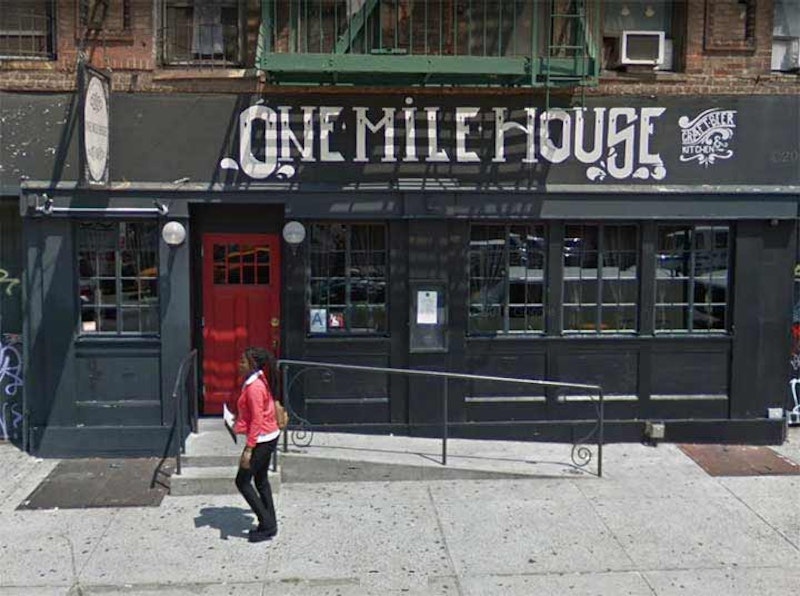
On Delancey St. between the Bowery and Christie St., you’ll find a tavern called the One Mile House (it has replaced its sign since this 2014 Street View photo). The Bowery’s an existing section of the Post Road, and the first mile marker was placed along the old road at about Delancey as it was one mile north of City Hall in the 1760s, located at Wall and Broad Sts. After the “new” City Hall was built in 1812, all of the milestones along the lengthy route had to be moved. Thus, the one-mile marker was moved to about Rivington St. and the Bowery. That marker survived until 1926, when a truck ran into it; however, there was a One Mile Tavern at Bowery and Rivington that lasted until the 1970s. This new One Mile House also recalls that milestone; it opened in the early-2010s.

According to The Milestones and the Old Post Road (1915) by George W. Nash and Hopper Striker Mott the Boston Post Road’s fifth mile marker was formerly located at 3rd Ave. and E. 77th St., but I imagine the Five Mile stone’s proprietors figured this location on the corner of 2nd Ave. and E. 85th St. in Yorkville was close enough. Just about all traces of the road have vanished in Manhattan, as it fell into disuse in the early-to mid-1800s as the street grid system was built on the island from south to north.

Dipping into the fantastical Robert Bracklow collection from the New-York Historical Society, here’s a look at the aforementioned Boston Post Road 12-mile marker in 1912. It appears someone has outlined the original chiseled letters in the marker with chalk or white paint. If you look at then and now, the stones in the wall have been moved around, likely more than once since 1912 during renovations.

As mentioned earlier, the Boston Post Road 12-mile marker was originally placed on the Post Rd. (later Kingsbridge Rd. and later, Broadway) and where 190th St. is now, but when distances were recalibrated with 0 at City Hall, the stone was moved to about 203rd St., where it was later abandoned. Over the years the writing on the stone has weathered off, or was chiseled off by vandals.
How did the marker wind up here? Isham Park (pronounced EYE-shem) was instituted in 1911. Before that, the park was part of the acreage of William Bradley Isham, a merchant banker who purchased 34 acres in 1867 from the family of dentist Floyd Ferris. According to NYC Parks, when Isham constructed the wall, he placed the marker there; it had been curbside but was discarded by roadworkers on Broadway. Parks doesn’t say what year Isham did this.

On a jaunt in Flushing I was surprised to see the five-mile marker of what is now Northern Blvd. beside the front driveway of Kingsland Homestead on 138th St., the home of the Queens Historical Society. Northern Blvd. was built in 1859, and opened to traffic in 1860, between what is now Vernon Blvd. and the Flushing River by the Hunter’s Point, Newtown and Flushing Turnpike Company. It connected to roads further east past the Flushing River, but the newly-built stretch was named Jackson Ave. for the turnpike company’s construction supervisor, John C. Jackson. By 1920, most of the road had been renamed Northern Blvd., with the westernmost section between Vernon Blvd. and Queens Plaza retaining the old name.
Jackson continued the colonial practice of placing milestones along his new route. Each marker showed the distance between the 34th St. Ferry at the East River, and also the distance to the bridge crossing the Flushing River. By 1916, only three Jackson Avenue mile markers still stood: the five-mile marker to the 34th St. ferry, at Grinnell Ave. (100th St.); the three-mile marker near 51st St. (Old Bowery Bay Rd.); and the two-mile marker near Steinway St. The five-mile marker survived in place, amazingly, until 1987 when it was removed to the Langston Hughes Queens Library branch in Corona. Now, it’s here at the Kingsland Homestead.

Ocean Parkway in Brooklyn was built between 1874 and 1880 in mid-Brooklyn from Prospect Park south to Coney Island. A milestone was placed every half-mile, but over the decades, every one had disappeared or was removed by 2000 except the three-mile marker, south of Ave. P, and the five-mile marker at Neptune Ave. After road repair crews discarded the five-mile marker in 2010, which was severely damaged in any case, only the three-mile marker remains.
Bklyner has more including research by me and by Gravesend’s Joseph Ditta; and Ditta produced a map showing the original locations of the milestones based on research by Richard J. Koke.

Photo courtesy Brian Hedden.
The milestone of Milestone Park, 18th Ave. and 82nd St. in Bensonhurst, Brooklyn, is a replica of the oldest remaining milestone in New York City. The original, seen here on 18th Ave. in the early-20th century, was moved to the Brooklyn Historical Society in the 1970s; a granite reproduction occupies the same spot where the original was placed on Kings Highway in 1741. One side reads, “8-1/4 Miles to New York Ferry and 2-1/2 Miles to Denyse’s Ferry.” (The New York Ferry was at the northern end of Fulton Street; Denyse’s Ferry in Bay Ridge under today’s Verrazzano-Narrows Bridge). The other is inscribed, “10-1/2 Miles to New York Ferry, 15 Miles to Jamaica.” The Friends of Historic New Utrecht, a neighborhood group, would like to see the original milestone put back.
—Kevin Walsh is the webmaster of the award-winning website Forgotten NY, and the author of the books Forgotten New York (HarperCollins, 2006) and also, with the Greater Astoria Historical Society, Forgotten Queens (Arcadia, 2013)