
Todt Hill, Staten Island’s 412-foot tall mountain, is in the center of the borough and is at once wild, wide-open and untrammeled and is one of Staten Island’s most exclusive and expensive areas… for people on both sides of the law. Join as I climb and ascend the hill, located between Clove Lakes and New Dorp.
You won’t find the word “todt” in the modern Dutch dictionary, not in the context of “dead” or “death.” The modern Dutch words are different. “Todt Hill” is most often said to mean “dead hill” or “death hill” using a regional or archaic Dutch term, and the most likely story is that the hill is named for 113-acre Moravian Cemetery at the bottom of the hill at Richmond Rd. However, the road can be found as “toad hill” on some old maps, which is likely merely an English bowdlerization.

We begin at the northeast corner of one of the busiest intersections in Staten Island, two colonial highways, Victory Blvd. (formerly Richmond Turnpike) and Clove Rd. Alone in a field stands the John Frederick Smith farmhouse at 1213 Clove, owned and restored by Dorothy Valentine Smith, who also occupied the adjoining John King Vanderbilt House at 1197. Both houses date to the early- to mid-1800s. Dorothy V. Smith wrote several historical books about Staten Island and helped found the Historic Richmond Town collection. Each house has been unoccupied since 1984.
On the northwest corner is a Citgo gas station and Dunkin’ Donuts that, according to old records, stand atop the Old Clove Baptist Church Cemetery, established in 1809; it was becoming overgrown by the 1890s and all but obliterated by the 1970s. However, the old cemetery’s presence explains why Clove Lakes Park doesn’t occupy the space. Two tombstones were discovered there by the Friends of Abandoned Cemeteries in 1998.

Think Sunnyside in NYC and you’d ordinarily think Sunnyside, Queens, but Staten Island has its own Sunnyside south of Clove Lakes Park along Victory Blvd., named for a former roadhouse at the corner of Victory Blvd. and Clove Rd. The Vanderbilt family was attracted to this former fox hunting grounds early and constructed several homes in the area in the 1840s. Streets in the area are named for Indian tribes and Vanderbilt in-laws.
At Northern Blvd. and Labau Ave. is St. Nicholas, the smallest Roman Catholic Church I’ve ever seen, at least in the five boroughs. It’s a chapel of St. Teresa on Northern Blvd. Sunnyside, Staten Island has a Northern Blvd., just as Queens’ does. Queens’ Northern Blvd. is one of the lengthiest roads in Long Island and, as Route 25A, reaches to Orient Point at the tip of Long Island’s North Fork. Staten Island’s Northern Blvd. runs only about four blocks.

Todt Hill as seen from Fine Blvd. and Todt Hill Rd. It’s a gradual climb, but insistent. The radio tower, transmitting WSIA 88.9 FM of the College of Staten Island at the summit is one of a few in the area. Todt Hill Rd.’s sidewalks drop away once you get south of Tillman St. and the local routes have no sidewalks and shoulders to speak of. A walk up or down Todt Hill Rd. between Tillman St. and Richmond Rd., or most of its length, means dodging some very busy auto and truck traffic—and the road bends and turns often.

At the southwest corner of Ocean Terrace and Todt Hill Rd., the Blue Trail, marked by blazes, winds northeast past high hills made of serpentine stone. Eventually you’ll end up at the abandoned ramps that were supposed to connect the Staten Island Expressway to “Moses’ Folly,” what was going to be an extension of Richmond Parkway (now Korean War Veterans Parkway) which ends at Richmond Ave. and Arthur Kill Rd. Moses was stopped in this attempt and the concept was finally abandoned in the early-1970s; it’s now part of Staten Island’s greenbelt instead. I’ll probably follow the trail in winter when the leaves are down. The unused remnants of this aborted highway were demolished a few years ago. Tillman St. at Townley and Motley Aves. was originally going to be the Richmond Parkway service road. The highest point in Staten Island is nearby, though I didn’t want to tramp through the woods to reach it; it’s in the vicinity of the radio tower.
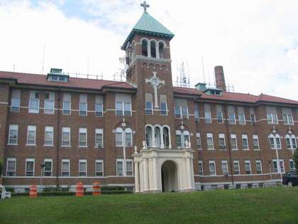
Just south of Ocean Terrace on Todt Hill Rd., behold the St. Francis Friary and Center for Spirituality, 500 Todt Hill Rd.. I felt a little funny creeping about snapping pictures, but nary a soul or Brother accosted me. It was built as a Roman Catholic seminary in 1928. The surrounding “parkland,” really wilderness area, was purchased by New York in 1997, and has been maintained as the same woods as it was when seminarians sought quietude, with blazed park trails, kettle ponds, spreading trees and only the occasional radio tower. Recently, the friary has become Our Lady of Zeitoun Coptic Orthodox Church. The Copts, or Egyptian Christians, have a number of strongholds on Staten Island, in Todt Hill, Great Kills and Tottenville.


Jasper Cropsey (1823-1900) was born on Staten Island, in what’s now Rossville. He became one of the greatest landscape artists of the Hudson River School, while he depicted locales all along the east coast, including the White Mountains of New Hampshire. His studio “Ever Rest” in Hastings-on-Hudson is open to tours, and he and his wife Maria are buried in Sleepy Hollow Cemetery in that recently renamed Hudson River town.
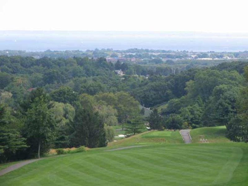
In 1895 Cropsey painted the view of New Dorp, Raritan Bay and the New Jersey Highlands (“Looking Oceanward from Todt Hill”) then obtainable from Todt Hill, which doesn’t turn up online, but can be found in the Staten Island Institute of Arts and Sciences in St. George.
And the view itself is still obtainable too. But how to get there?
Find an almost-unmarked pathway called Helena Rd. that drifts off to the west from Todt Hill Rd. Don’t mind the “private” and “no trespassing” signs; they’re there mainly to protect yet another radio tower that’s just ahead. (The Parks Department maintains blazed trails here.) You’ll pass by a number of expensive mansions before Helena makes an abrupt right turn, and then another left.
We’re now on Cliffwood Ave., which Helena becomes after the turn. It splits into two: take the right fork, which runs past some lighted gateposts that mark another estate. Cliffwood Ave. seemingly ends at a driveway leading into a big mansion with a yard, but follow the muddy trail a few more yards and you’ll come upon the Blue/Yellow Trail, marked generously by Parks. Turn left and follow the path toward a clearing and you’ll see what looks like a fairly generic patio-like setting. This is the Cropsey Outlook.
The reward is the breathtaking view shown here. This is the same view Jasper Cropsey had when painting “Looking Oceanward from Todt Hill,” with the addition of the Richmond County Country Club in the foreground. Use your camera zoom lens, and you’ll get a good look at Raritan Bay at the horizon.

Has a White House replica been built at Four Corners and Todt Hill Rds.? A nearby Benedict Rd. house resembling this one belonged to Mafia capo Paul Castellano, who was killed on orders from rival John Gotti in a classic rubout at Sparks Steak House in December 1985. Castellano is now in Moravian Cemetery (see below).

From the 1600s to the end of the American Revolution, Todt Hill was known by the Dutch name Yserberg (Iron Mount) for its exceptional iron resources. Evidence of iron mining on Todt Hill dates to 1644, but it’s known that intensive mining took place between 1832 and 1881. In 1832, Walter Dongan granted Warmaldus Cooper permission to mine the land at the intersection of Ocean Terrace and Todt Hill. Business boomed in 1865 when iron ore was discovered in the serpentine rock that stretches from the Kill Van Kull to Fresh Kills. Because the iron lay close to the surface, it could be extracted with relative ease. By 1881, more abundant sources had been found in the west, and mining activity on Staten Island slowed.
Ernest Flagg (1857-1947) was one of NYC’s most prolific architects. Among his creations were the Singer Tower in lower Manhattan (1908-1968) as well as the expansive Flagg Court complex on Ridge Blvd. in Bay Ridge, Brooklyn. Flagg once believed that Staten Island would become NYC’s premiere borough, and it prompted him to build his huge estate, Stone Court and Cooperflagg Estates (remembering the name of the land’s original iron miner), on the scarp separating Todt Hill from the neighborhoods below it along Richmond Rd. Many of the buildings are now landmarked while others are part of St. Charles Seminary.

Moravian Cemetery was established in 1842 but there have been burials at what would become Moravian for over 250 years. Staten Island’s foremost scientist and historian of his era, William T. Davis, discovered in 1930 headstones here going back to 1740. Before incorporating as Moravian Cemetery, it was known as “The Congregation Ground.”
Moravian, the Green-Wood of Staten Island, is the premier cemetery in the borough and its gravestones read like a Staten Island gazetteer. Painter Jasper Cropsey, Eberhard Faber of the pencil manufacturing family, Herman Melville’s brother Thomas (who ran Sailors’ Snug Harbor from 1867-1884), photographer Alice Austen, and the aforementioned William T. Davis and Charles Leng, Staten Island historians. Martin Scorsese has purchased a plot here.
In the back of Moravian Cemetery is the adjoining private plot of the Vanderbilt family, featuring a massive tomb high enough on Todt Hill to be seen from approaching ships in Upper New York Bay. It was constructed in 1885 by the foremost architect and landscaper of their time, Richard Morris Hunt and Staten Islander Frederick Law Olmsted.
We have come to the bottom of Todt Hill, where traffic is fed onto another ancient colonial-era path, Richmond Rd.
—Kevin Walsh is the webmaster of the award-winning website Forgotten NY, and the author of the books Forgotten New York (HarperCollins, 2006) and also, with the Greater Astoria Historical Society, Forgotten Queens (Arcadia, 2013)