
New York City has Main Streets long and short in each borough (Brooklyn’s Main St. runs for three blocks, while Queens’ runs for several miles) and a Broadway in each borough, with Manhattan and the Bronx sharing the same one. There’s a Wall St. in St. George, Staten Island and a Park Ave. in Fort Greene. At the same time, New York City has several separate numbering systems, and four boroughs out of five have a 1st St.
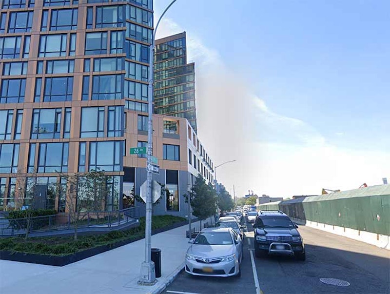
Queens’ 1st St, is the hardest to find. At the very edge of Astoria Village facing the East River, it runs for two blocks, from 26th Ave. at Whitey Ford Park south to a dead-end stub of Astoria Boulevard in the Astoria Houses. Pictured here is the new development 10 Hallett’s Point, a vanguard of the increasing number of high-rise apartment houses now invading this heretofore quiet enclave.
This is the edge of Astoria Village, a dwindling enclave of picturesque buildings dating back to the mid-1600s, when William Hallett received a grant for the area surrounding what is now Hallett's Cove by Peter Stuyvesant. However, the oldest structures in the region date to the mid-1800s, after fur merchant Stephen Ailing Halsey had incorporated the village in 1839.
Hallett's Cove today, the region in Astoria just south of Astoria Park and west of 21st St., is today a mixture of breathtaking houses, ancient churches and graveyards, as well as forbidding, utilitarian housing projects and industrial buildings. The area near Astoria Park, as well as Ditmars to the north, feature views of the Hell Gate (1910) and Triborough (1936) bridges. It's typical of the resolute nondevelopment of New York City's waterfront that the closer to the water you get, the more boring it is.
Virtually nothing remains of William Hallett's original settlement along the cove that today bears his name (flags along the neighborhood's streetlamps call this area Two Coves—Hallett's Cove proper, at Vernon Blvd. and Main Ave. where they meet the East River, and Pot Cove, at the foot of Astoria Park South and Shore Boulevard). It was only after Stephen Halsey incorporated a village here in 1839 that streets began to radiate east and south from the area. Most of them were named for local landowners. Even if you didn't notice the old-style Victorian buildings found in the area, its age can be detected by the narrowness of some of its streets as well as the irregularity of its street pattern; 12th St. changes directions three times, and 26th Rd. slants askew its neighbors. Astoria Village is centered at 21st St., Astoria Blvd. and Newtown Rd. West of here, the streets seem more timeless, with old churches, narrow sidewalks and hidden cemeteries, while east of here, it’s more conventionally Queens-like.

Western Brooklyn’s street numbering system begins in Park Slope, beginning with 1st St. and going south to the Narrows, ending at 101st St. When the streets were laid out and given names, the numbered streets begin at an arbitrary location, south of a gathering of patriotically named Union St., President St., Carroll St. and Garfield Pl. First St. runs in a straight line from 3rd Ave. east to Prospect Park West.
There’s a landmark at 3rd Ave., part of the wall from Washington Park, a former major league baseball stadium, but not the American or National League. The Brooklyn Bridegrooms/Superbas/Dodgers played at this location at various times, between 1883 and 1912, after which Charles Ebbets moved the Brooklyn National League club to the new park that bore his name in Lefferts Gardens, where they remained until they moved to Los Angeles in 1958.
Most research now shows that the wall belonged merely to the Brooklyn franchise in the Federal League, a rival major league created to compete with the National and American Leagues (Wrigley Field, originally Weeghman Park, was also built for the Federal League Chicago franchise). In 1914, the Brooklyn Tip-Tops of the Federal League moved in, and Robert B. Ward, who owned the Tip-Tops as well as Tip-Top Bakeries, surrounded the park with a cement and brick wall. The Federal League went out of business at the close of the 1915 season, but the wall’s still here. Part of it, anyway, since property owner Con Edison demolished the section facing 3rd St. years ago.
Follow 1st St. up “the Slope” to Prospect Park, a pleasant stretch of Brownstone Brooklyn. Have a slice at Two Boots Pizza on 5th Ave., and stick your nose into some of the eclectic shops found on 7th Ave. Brooklyn has numerous other 1st Sts.

East Houston St. divides the club of streets with names of southern Manhattan Island from the fraternity of streets with numbers (and a few letters) on the island north of it. At E. Houston, Columbia becomes Ave. D; Pitt becomes Ave. C; Clinton becomes Ave. B; Essex, Ave. A; Allen, 1st Ave.; and Chrystie, 2nd Ave. West of that, no numbered avenue gets as far south as Houston except 6th Ave., and it didn’t do so until 1928, long after the overall grid pattern was set.
E. Houston St. has been monkeyed with repeatedly since it was first laid out in the early-19th century, though most of the shenanigans happened during the 20th century. Before 1933 or so, it was a narrow two-lane street, comparable in width to its parallel pals Stanton, Rivington and Broome. In the early-1930s, most of the buildings on the south side of the street were condemned between Essex and the new 6th Ave. southern extension so that the IND subway—now the F train—could be built more easily under the street. That left Houston with a lot of empty lots that were filled with transient structures and shacks until a general street widening, making Houston the roaring throughfare it is today, was begun in 1957 and completed in 1961.
Houston doesn’t run parallel to the east-west street grid that it partitions from downtown. Both E. 1st St. and E. 2nd run into it before Houston St. itself is brought to a close at the FDR Drive. This situation makes for some unusual parks and triangles. A quirk in the street grid layout brings 1st Ave. and E. 1st St. together just a nick north of Houston. Nearby, 2nd Ave. and E. 2nd also intersect. That’s the sum total of intersections in Manhattan with the same number.
There are none in the Bronx or Staten Island; Brooklyn has a few in Park Slope; and Queens, with its overwhelming street numbering, has dozens.
At the intersection, you’ll find the One on One Tavern; First Park; and Peretz Square, the narrow green spit east of 1st Ave. filling the triangle as E. 1st St. gradually succumbs to running into E. Houston and ending before it reaches Ave. A. The “square” was named in 1952 for Isaac Loeb Peretz (1851-1915), an attorney, author, essayist and poet born in Poland under Russian rule. He wrote primarily in Yiddish and was known as the “Great Educator” of the Jewish masses.
The Nexus Lounge, which shares space with the One and One tavern, is cleverly named. On a Seinfeld episode, Kosmo Kramer is lost downtown at 1st and 1st, which he says, “must be the nexus of the universe.”

Alone among the five boroughs, Staten Island isn’t reliant upon a street-numbering system. Though there had been some numbered streets in different towns before Staten Island joined New York City in 1898, all of the island’s numbered streets have been winnowed out, except for New Dorp, where there are numbered streets from one to 10.
“New Dorp” is a transliteration of Dutch nieuw dorp, or “new town,” so-called because it was settled in 1670, 10 years after nearby “oude dorp,” a name remembered in the street name Old Town Rd. The town grew up around the junction of Richmond and Amboy Rds., where there were taverns serving stagecoaches and horse-drawn carriages. The Vanderbilt family was prominent in the area and owned racing and trotting tracks in the area. The family helped found the New Dorp Moravian Church and Cemetery along Richmond and Todt Hill Rds.; the Vanderbilt Mausoleum, built for $1 million and designed by Richard Morris Hunt, can be found at the cemetery’s rear section.
In New Dorp, 1st St. is the shortest of its numbered streets, running about two blocks between Richmond and Amboy Rds. It’s the most suburban of New York City’s First Streets, and a quick, pleasant stroll.
—Kevin Walsh is the webmaster of the award-winning website Forgotten NY, and the author of the books Forgotten New York (HarperCollins, 2006) and also, with the Greater Astoria Historical Society, Forgotten Queens (Arcadia, 2013)