

Getting older, I think more about what will become of the photo collection I have amassed in nearly 30 years of NYC photography. In the short run, my associate organization, Greater Astoria Historical Society, has the various passwords needed to access my website forgotten-ny.com and would keep it going, but my main concern is the hundreds of scanned hard copy photos and thousands of digital photos at home on my desktop and in the cloud. I’d like to have a plan in place for their disposal upon my demise. If anyone has ideas, let me know via PM on Facebook or by my email, kevinjudewalsh@gmail.com.
In Forgotten NY’s early days, photos were scanned small—in some cases no more than 4.5 inches width. That’s because I wanted to keep sizes as small as possible in an era of dial-up modems. I’ve sifted through my hard copy photos, picking out the best and rescanning them larger.
Pictured above are some pals and acquaintances on the abandoned Long Island Rockaway Beach branch in Rego Park, an active train route until 1962. At left is the tour leader, the late great railroad and maritime photographer Bernard Ente. The old route is under consideration to become a linear park called QueensWay, and construction will soon begin on its first few blocks.
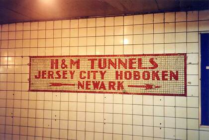
The Port Authority Trans-Hudson Railroad, or the PATH train, is NYC’s “other” subway, running under 6th Ave., Christopher St., Greenwich St. and Morton St. and from Church St. at the World Trade Center site to various stops in Hoboken, Jersey City, and Newark, New Jersey. At its full length, it runs from one block away from NYC’s Pennsylvania Station to Newark’s Penn Station.
An ambitious lawyer from Georgia via Tennessee, William Gibbs McAdoo, obtained backing and employed upgraded tunneling methods in 1901, doing what was considered impossible: he engineered multiple tunnels and inaugurated rail service, the first trans-Hudson rail of its kind, between NYC and Hoboken, from 1908-1910 and Jersey City and Newark Park Place in 1911. The Independent Subway (IND) helpfully included directional signs to the H&M tunnels. These signs were unveiled in 1940 at the 14th St. station serving F trains, and uses the abbreviation for the Hudson and Manhattan Railroad, PATH’s old name.
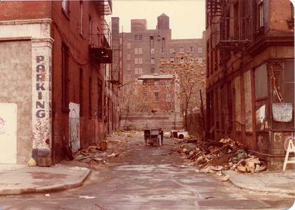
I’ve covered Extra Place, on E. 1st just east of the Bowery, many times but have never made this the title image. It’s emblematic of the decrepitude parts of NYC fell into in the late-1970s and the abyss wasn’t plumbed until the 1990s, when the comeback, at least infrastructurally, began. In 1978 Extra Place was open to auto traffic, but as you see here it was blocked by an air conditioner someone had placed there. Extra Place, in good times, was the service alley for businesses along the Bowery, and a back door at CBGB, at Bowery opposite Bleecker, opened onto the alley.
Extra Place received its name when E. 1st was laid out in the 1820s and plots were divided up. There was a leftover patch which became Extra Place, one of Manhattan’s few dead-end alleyways.
In this view you can see a house on E. 2nd that’s long demolished. The tall building in the background is the Bowery YMCA on E. 3rd Street, now home to the Renewal on the Bowery homeless assistance agency. The building went up in 1915. The YMCA has a lengthy history assisting the unfortunate on the Bowery, and was a neighborhood presence since 1872. The YMCA moved out in 1947, but the building’s been home to homeless assistance agencies since then. Directly to the rear of the building you can find the New York Marble Cemetery.
To pass Extra Place today you’d never know it had sunk so low. A new adjoining building is part of the Avalon apartment complex; today Extra Place is pedestrian-only. In the ebb and flow of NYC, it may someday be decrepit again and then revitalized again.
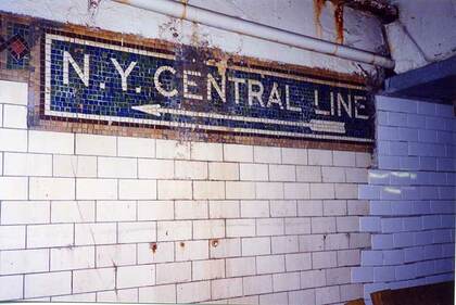
The E. 149th St. station serves #2, 4 and 5 trains on their way to midtown Manhattan or north to Wakefield, Woodlawn Cemetery, or Dyre Ave., in two separate trackways on two levels. It’s a complicated complex that was the first Interborough Rapid Transit subway station in the Bronx when it opened in July 1905 (though the IRT el as far as E. 177th-East Tremont had already opened in November 1904).
Forward to 1917-1918, when the IRT built the present Jerome Ave. subway and elevated up to Woodlawn Cemetery. Corridors were constructed allowing transfer between the two trunk lines, and contained mosaic directional signs with slightly raised tiles, similar to most mosaic tiling you see in today’s subway. One set pointed to “the Jerome Avenue line,” today’s #4 train, but other signs, one shown here, pointed the way to the “NY Central Line.” The mosaic signs at the IRT station anticipated a walkway connection between the subway and railroad at 149th St., which seemed logical but never happened.
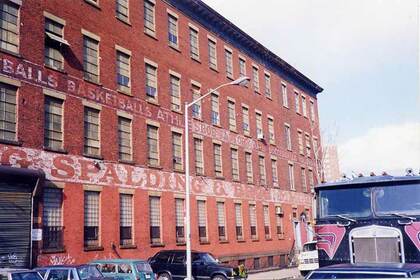
The A.G. Spalding manufacturing building at 6th Ave. and Pacific St. in Park Slope, where they used to make the rubber “spaldeens,” still had its old ID markings when I first visited in 1999. It was subsequently remade into residential units, but ultimately torn down by 2010 to make way for the ongoing Pacific Park development, whose most notable building is the Barclays Center, home of New York’s “other” NBA team, the Brooklyn Nets.
Al Spalding (1850-1915), a baseball Hall of Famer, was the first professional pitcher to win more than 200 games, in his late 19th-century career (he won 47 games for the Chicago White Stockings in 1876). Spalding went on to a successful career producing baseball guidebooks and later, baseball and other sporting equipment.
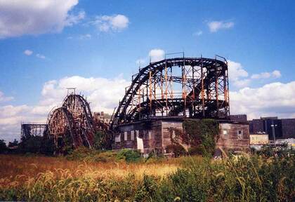
There used to be a house under the now-demolished Thunderbolt roller coaster in Coney Island. The house, which used to be the Kensington Hotel, was built in 1895 and the Thunderbolt was built over it. The situation was memorialized in Woody Allen’s movie Annie Hall. The last owner of the house was the coaster’s owner, Fred Moran; a friend, Mae Timpano, occupied the house till 1988 when the property was sold to developer Horace Bullard. A caretaker occupied the house until almost the day of demolition. The Thunderbolt closed for business in 1983.
The ‘coaster was torn down in fall 2000. Apparently it was deemed too unstable to remain standing any longer (though depending on who you believe, Mayor Rudy Giuliani wanted it torn down because developers of the adjacent Mets’ minor league park considered it an eyesore). It was built by famed roller coaster designer John Miller in 1925, so the structure lasted an even 75 years.
—Kevin Walsh is the webmaster of the award-winning website Forgotten NY, and the author of the books Forgotten New York (HarperCollins, 2006) and also, with the Greater Astoria Historical Society, Forgotten Queens (Arcadia, 2013)